Didn't see a 2023 Tropical weather thread so.
Everyone in FL ready?
We are expected to get 6 to 10 in of rain up this way which given the amount of rivers creeks and swamps around here will make things quite interesting.


Didn't see a 2023 Tropical weather thread so.
Everyone in FL ready?
We are expected to get 6 to 10 in of rain up this way which given the amount of rivers creeks and swamps around here will make things quite interesting.

That's more rain than we've had this year.Originally Posted by ccmdfd

In the P-F basket of deplorables.

Not supposed to be anything but rain bands here, so there's not much to do. Looks like the Cedar Key area is going to get the worst of it.
"Gunfighting is a thinking man's game. So we might want to bring thinking back into it."-MDFA
Beware of my temper, and the dog that I've found...

Current models are showing it as a category 3 storm when it makes landfall, and considering that the models have trended to forecasting weaker storms in the gulf basin than what they end up as I dont think we can rule out it being a stronger than a cat 3 by the time it makes landfall.
im strong, i can run faster than train
I remember Camille in 69. I was in Pensacola which was nowhere near the eye, maybe 100 miles away. The rain was sideways and winds about 70 mph. You couldn't stand up in it. Unbelievable.
In the P-F basket of deplorables.
A friends son bugging out of Tampa.

Code Name: JET STREAM
Models are models, but today's 00Z HMON and HWRF have it making landfall as a Cat4, while the 00Z GFS has it just into Cat3 pressure.
That posted, you need SMEs to interpret and give their best prediction based on all data. The NHC's discussion page for each storm is updated every six hours. Levi Cowan of Tropical Tidbits posts a long video each day.
https://www.nhc.noaa.gov/text/refres...l/290859.shtml
"Gunfighting is a thinking man's game. So we might want to bring thinking back into it."-MDFA
Beware of my temper, and the dog that I've found...

Yeah, basically. We are an hour or so North West of Orlando, on fairly high ground, perhaps 120 miles from the Big Bend area of Florida. I'll get the patio furniture in today but don't expect much other than high wind and lots of rain. Filled up the truck yesterday. We've got water and food, including a couple boxes of long-life water cartons and a box of MREs we got after Hurricane Ian. Still have my small Champion 2.5 kW genny for power if we need, and a gas grille. I think we'll be ok, no plans to bug out at this time. And we don't have an RV to worry about anymore. But to be honest this is what anyone in Florida who is paying attention does every year anyway; it's not like this hasn't happened before. At least with Hurricanes, you can see them coming, not like Tornadoes and such.
All I've seen of the models has it going on shore as a Major between Steinhatchie and Crawfordville, SE of Tallahassee. Somewhere near Perry. Which absolutely sucks, but, if there's a place in Florida with sparser than average population, it's there. Tampa Bay is going to get filled up, as they are on the windy side of the storm. Probably a fair bit of localized flooding, unfortunately, as high winds drive water in, especially if it passes by at high tide. And it's going to be a bad day in Jax on up to Savannah. Hopefully it will burn itself out by then to a Cat 1 or TS even.
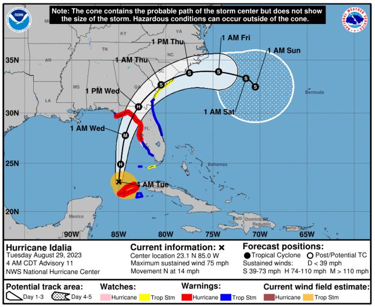
I usually keep an eye on the static wind speed track line at NHC. This is today's 4AM CDT update. Moving North at 14 mph is a good thing.
Last edited by RJ; 08-29-2023 at 05:29 AM.

Pensacola seems to skate through hurricanes nowadays?
#RESIST
Good luck to all. Got some family in the path if it crosses the Carolinas. They usually evacuate to other family in Virginia.
Cloud Yeller of the Boomer Age

 Reply With Quote