We've had 4 tornado warnings in the past hour. Don't know if any of them were actual touchdowns.


We've had 4 tornado warnings in the past hour. Don't know if any of them were actual touchdowns.
Two weeks later we are still dealing with the aftermath of this storm. Weve finally finished all of the demo work, and are waiting on the insurance cos and builders to get in and actually make the necessary repairs.
We have been hit with 4 storms in the past 5 years. Thats the same # of storms weve been hit by in the proceeding 47+ years combined. I hope its just a blip on the curve.
Some things Ive learned from all of these:
If its your property which is damaged/destroyed, it doesnt matter if its a springtime thunderstorm or a Cat 5 monster. It sucks.The only direct correlations with the category on the Saffir- Simpson scale are: The number of friends whom you havent seen since high school who suddenly call/email/facebook you to see how its goingThe number of out of towners who come in and drive 5 mph and point at everything they can see wrongHow much time you get on the MSMs coverage.
What actually matters in terms of storm damage are the specifics of the storm (track, speed of travel, etc) as well as local topography. For instance, in this part of NC the beaches run E-W, if you walk directly out into the ocean you are headed south. For us, and a northward travelling storm, being on the storms east side is bad, the northward headed winds are augmented by the storms forward motion, and the storm surge is also worse due to the winds pushing the sea onto the south facing beaches. Thats exactly what this storm did. Most of our usual storms scoot up the coast and we stay on their west side, and dont suffer the same problems.
Tornados are, to use a term often used on gun forums, force multipliers. A weak hurricane with several tornados can out damage a stronger storm with little to no tornados. We got 3 of them in this county. Tornados also carry the damage to areas not typically affected by the hurricane. My wifes hometown, hours inland, had 2 deaths due to a tornado with this storm.
High tide and full moons are also force multipliers. High tide during full moon converts things to a log scale, and this is what happened with this storm.
Around here, the yardstick storm is Hazel, everything is compared to it. It was a cat 4 storm from 1954. Prior to Hazel, Oak Island was a single island with 350ish houses. Afterwards, it was two separate islands (it cleaved OI in two) with a grand total of 3 houses left standing.
This storm was no Hazel, the damage was more limited, but where the damage was done, it was equivalent to Hazels.
There are no more sand dunes on Oak Island. They were washing inshore (they have been actively trying to build them back).
The storm surge levels in Southport reached Hazels (although officially much lower, the people who lived through both will tell you that the level on their front steps that the river came to was the same for both storms).
Southport Marina is closed and will be so for 4-6 months. There are several hundred boats all pilled together into one giant heap, and many others were carried away by the surge.
4 houses burned down on Ocean Isle Beach due to the saltwater shorting out car electrical systems, and the cars were parked under the houses as is typically done with beach cottages on stilts.
Anyway, it sucks.
Dont downplay a storm because its a minor one, you need to look at the specifics of how its going to travel (Florence and Floyd both caused massive devastation because they slowed down and dumped foot upon foot of water causing massive flooding), where its going to travel, and time its going to hit.
cc

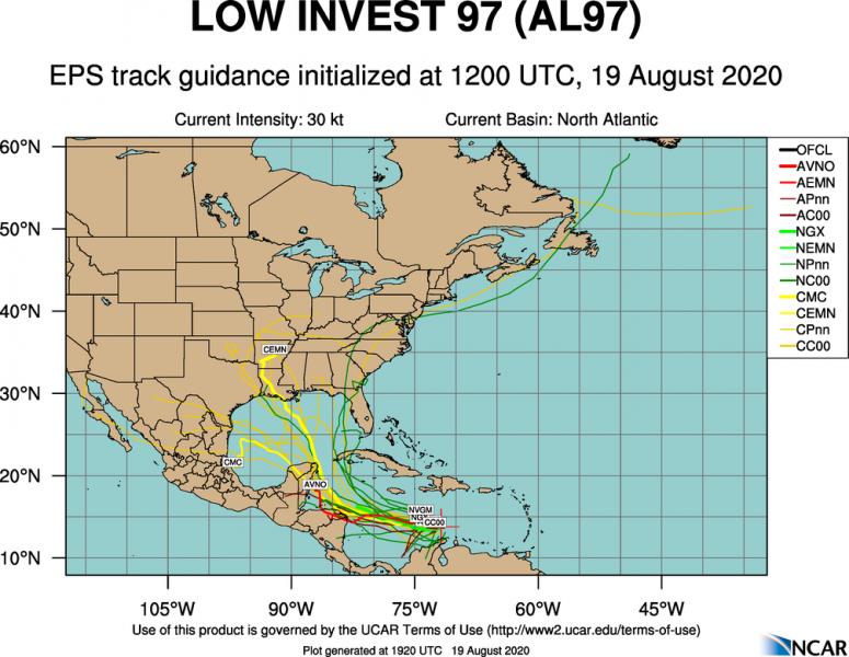
Looks like things are starting to get cranked up pretty good in the tropics now with three tropical systems showing a high probability of development.
im strong, i can run faster than train

Well, going to need to keep an eye on this on, TD13:
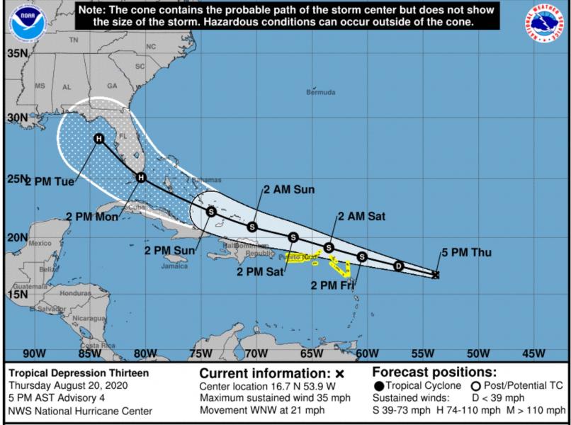
It should be interesting as both are due to make landfall on the Gulf Coast on the same day.
Yeah Id forgotten about TD14.Originally Posted by JTQ

2020 sucks.
Ooooooh!
Maybe they could Fujiwhara.
https://en.m.wikipedia.org/wiki/Fuji...essure%20areas.
At least that's what all of the self described meteorologists on the old Wunderground blog would be screaming about now. (by self described I'm talking about the posters with zero credentials, not the men who ran the blog )
I was wondering if the rotation would cause something like that, since I live near the center point between the two tracks.
The two vortices will be attracted to each other, and eventually spiral into the center point and merge.
Hmm, I have family in Houston and Orlando. Better get the guest room ready.

 Reply With Quote